

Sentinel
Sentinel
Couldn't load pickup availability
✓ Instant download after purchase
✓ Single HTML file — no install required
✓ Runs locally in a modern web browser on Windows, macOS, or Linux
✓ One-time purchase — perpetual-use license
✓ U.S. sales only at this time
What is Sentinel?
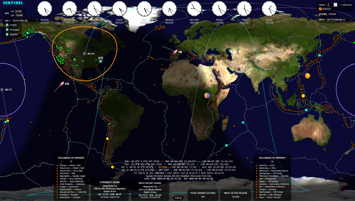
Sentinel is a live-refreshing Earth and space situational-awareness display built for operators, educators, preparedness users, and technical professionals who want a current picture of global activity — without the overhead of heavyweight systems.
It runs full-screen in a modern browser on Windows, macOS, and Linux. No server. No account. No installation. Open the file, set your local reference location, and you're operational in under 60 seconds.
Sentinel is a focused situational-awareness tool for people who want authoritative public information at a glance: seismic activity, geophysical context, satellite visibility, grayline, and local reference conditions in one always-on display.
Is Sentinel right for you?
🌍 Situational Awareness Professionals
You monitor global events, seismic activity, geophysical patterns, hazards, and environmental context. Sentinel pulls authoritative public data sources and renders them clearly on a single operational display.
🎓 Educators & Outreach
You run demonstrations, classroom displays, public outreach, or training sessions. Sentinel works on any screen, needs no IT setup, and presents a live public-data picture of Earth and space that engages any audience.
🛰️ Radio & Satellite Operators
You track ISS passes, monitor satellite visibility, or want orbital context relative to your location. Sentinel shows your local reference location — also called QTH by radio operators — with footprint coverage, AOS/LOS timing, and satellite context without cluttering your workflow.
Key Capabilities
Satellite Awareness
- ISS and CSS always-on tracking with live latitude/longitude and orbital status
- SAT 1 and SAT 2 — selectable from a curated satellite list
- Footprint rings, clear "in-view" indicators, and adjustable orbital trails
- AOS/LOS timing for selected satellites based on your local reference location
- Embedded TLEs at startup — upgrades to live CelesTrak data when online
- Satellite tooltips: apogee, perigee, lat/lon, inclination, visibility status
Earth Activity
- Current earthquake activity from the USGS 24-hour global feed
- Magnitude-scaled markers with hover tooltips and event statistics
- Strongest quake, most recent event, event count, and most active region at a glance
- Feed status line: last updated, fresh/stale/offline indicator
Geophysical Context
- USGS curated volcano overlay — globally consistent markers with hover tooltips
- PB2002 tectonic plate boundaries for geophysical context
- Both overlays are toggleable and settings persist across sessions
Local Context
- Real-time grayline day/night terminator — updates continuously
- Local reference marker with weather snapshot and active NWS alerts where available
- Global city clocks for major time zones with UTC reference
- Persistent settings: your location and toggle states survive browser restarts
Operational Reliability
- Local-first: Sentinel runs on your machine. Live feeds refresh when internet is available.
- Offline-capable: embedded TLEs and the cached volcano catalog keep working without connectivity
- Unified feed-status line showing which data sources are fresh, stale, or offline
Technical Specs
System Requirements
- Browser: Current versions of Chrome, Edge, Firefox, or Safari. Chromium-based browsers are recommended.
- OS: Windows 10+, macOS 11+, Linux
- Display: 1080p or 4K recommended; other resolutions may work. Optimized for full-screen or dedicated second-screen use.
- Internet: Optional for core display functions; required for live feed refreshes such as earthquakes, weather/alerts, and TLE updates.
- Install: None. Open the HTML file directly in your browser.
What's Included
- Single self-contained HTML file (~1.1 MB)
- Embedded TLE data for immediate orbital display
- USGS volcano catalog (auto-refreshes when online, cached when not)
- Built-in help documentation (press H or F1)
License
- Single-computer, single-user license
- Maintenance updates and improvements may be provided at no additional charge when available. Future major versions, upgrades, or Pro editions may be offered separately.
- U.S. customers only at this time
Works alongside Guardian
Sentinel pairs naturally with Guardian, our space weather, propagation, and signal-environment situational-awareness display. Each product runs independently as its own single-file app — many users run both side by side.
Frequently Asked Questions
What happened to EarthView?
EarthView has been renamed to Sentinel. If you purchased EarthView, you own Sentinel. Your original download link remains valid for updates included with your purchase. Free updates are included for one year from your purchase date, within the purchased version track.
Do I need an internet connection?
No. Sentinel runs locally from your machine. When internet is available, it refreshes live feeds: earthquake data, weather/alerts for your location, and TLEs from CelesTrak. When offline, it uses embedded TLEs and the cached volcano catalog.
What's the difference between Sentinel and Guardian?
They serve different primary missions. Sentinel centers on Earth awareness: earthquakes, hazards, geophysical context, satellite visibility, grayline, and local weather/alerts. Guardian centers on the signal environment: space weather, propagation, solar and geomagnetic activity, and satellite visibility. Both track ISS and CSS. Many users run both.
Can I use this on multiple computers?
Your license covers a single computer and single user. If you need additional seats, contact us.
Is there a refund policy?
Yes — see our Refund Policy for details.